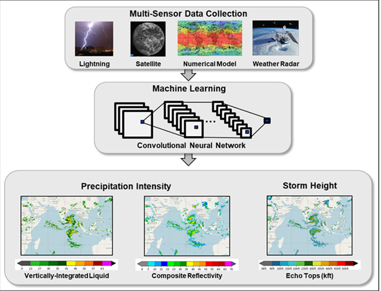
This image shows an overview of the Global Synthetic Weather Radar algorithm. Multiple (nonradar) inputs, such as lightning data, satellite imagery, and numerical weather model outputs, are fused using a supervised machine learning methodology trained against weather radar to create global weather radar-like images of areas outside the range of ground-based weather radars. Users can select whether to view the storm height or the precipitation intensity as represented by different metrics.
The Global Synthetic Weather Radar (GSWR) technology, from MIT Lincoln Laboratory and the U.S. Air Force, uses machine learning–based algorithms to provide radar-like weather imagery and radar-forward forecasts in global regions where actual weather radars are not deployed or available. The GSWR capability builds on a previous limited-domain version, the Offshore Precipitation Capability (OPC). The OPC was developed for the Federal Aviation Administration to provide weather information for flight planning and air traffic control purposes for offshore regions off the U.S. east coast, and that technology won an R&D 100 Award in 2016. GSWR required novel machine learning methods to incorporate new satellite, lightning, numerical weather model and radar truth data sources and to substantially scale up the capability from the continental United States domain to the global domain. This technology will provide valuable weather information to the U.S. Air Force to support mission planning for their worldwide operations, and it was deployed to their cloud computing environment in 2020. There are many civilian applications including aviation, water resources, and recreation that could also be enabled through wider GSWR deployment.


Tell Us What You Think!