Research & Development World

  • R&D World Home
  • Topics
    • Aerospace
    • Automotive
    • Biotech
    • Careers
    • Chemistry
    • Environment
    • Energy
    • Life Science
    • Material Science
    • R&D Management
    • Physics
  • Technology
    • 3D Printing
    • A.I./Robotics
    • Software
    • Battery Technology
    • Controlled Environments
      • Cleanrooms
      • Graphene
      • Lasers
      • Regulations/Standards
      • Sensors
    • Imaging
    • Nanotechnology
    • Scientific Computing
      • Big Data
      • HPC/Supercomputing
      • Informatics
      • Security
    • Semiconductors
  • R&D Market Pulse
  • R&D 100
    • Call for Nominations: The 2025 R&D 100 Awards
    • R&D 100 Awards Event
    • R&D 100 Submissions
    • Winner Archive
    • Explore the 2024 R&D 100 award winners and finalists
  • Resources
    • Research Reports
    • Digital Issues
    • R&D Index
    • Subscribe
    • Video
    • Webinars
  • Global Funding Forecast
  • Top Labs
  • Advertise
  • SUBSCRIBE

Suomi NPP Satellite Sees Depression Become Tropical Storm Darby

By Nasa/Goddard Space Flight Center | July 12, 2016

On July 11, the Suomi NPP satellite showed thunderstorms around Tropical Depression 4’s center of circulation, and bands of thunderstorms wrapping into the low level center from the western and eastern quadrants. Credit: NASA/NOAA/DOD

The Suomi NPP satellite captured a visible image of Tropical Storm Darby as it was developing in the Eastern Pacific Ocean.

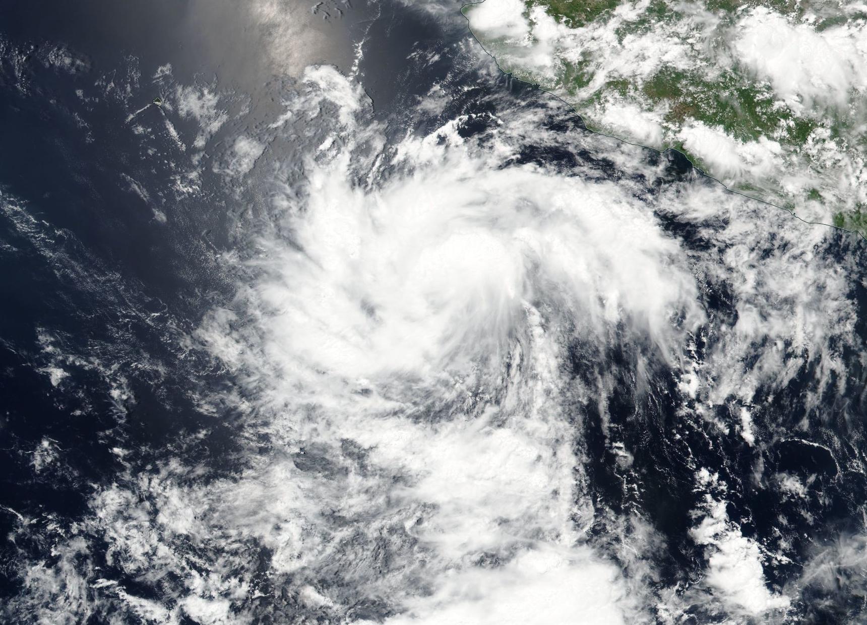
Tropical Depression 4 formed around 5 p.m. EDT off the coast of western Mexico on Monday, July 11. Soon after it formed he Visible Infrared Imaging Radiometer Suite (VIIRS) instrument aboard NASA-NOAA-DOD’s Suomi NPP satellite captured a visible light image of the storm. The VIIRS image showed thunderstorms around the center of circulation, and bands of thunderstorms wrapping into the low level center from the western and eastern quadrants. The depression continued to organize overnight, and by 11 a.m. EDT on July 12, the depression had become a tropical storm.

Forecaster Berg at the National Hurricane Center said “Recent microwave data indicate that the depression has a well-defined circulation with the center located to the northeast of the strongest convection.

At that time the center of Tropical Storm Darby was located near16.0 north latitude and 108.5 west longitude, about 345 miles (555 km) southwest of Manzanillo, Mexico. Darby was moving toward the west near 10 mph (17 kph) and that general motion is expected to continue for the next couple of days. The estimated minimum central pressure is 1006 millibars. Maximum sustained winds have increased to near 40 mph (65 kph) with higher gusts. Some additional strengthening is forecast during the next 48 hours, and Darby could become a hurricane on Thursday.

In a couple of days, depending on the track Darby takes, it may track over the cold water kicked up from Hurricanes Blas and Celia. Tropical cyclones need sea surface temperatures at least near 80 degrees Fahrenheit (26.6 degrees Celsius) to maintain strength. Cooler waters sap evaporation that help form the thunderstorms that make up tropical cyclones, while warmer waters enhance evaporation.

In addition, the NHC noted that there may also be some vertical wind shear affecting the storm for a few days, so it would only allow for steady strengthening in the next three days before the colder water adversely affects the storm.

According to NHC, after a quiet May and June, the eastern North Pacific season has already caught up to where it should be climatologically in terms of named storms.

Related Articles Read More >

Floating solar mats clean polluted water — and generate power
New AI model offers faster, adaptive CO₂ retrieval from satellite data
8 major R&D moves this week: Samsung invests record $24B while Porsche cuts 3,900 jobs
Ex-Google AI team launches “Generation,” an AI-driven fragrance venture
rd newsletter
EXPAND YOUR KNOWLEDGE AND STAY CONNECTED
Get the latest info on technologies, trends, and strategies in Research & Development.
RD 25 Power Index

R&D World Digital Issues

Fall 2024 issue

Browse the most current issue of R&D World and back issues in an easy to use high quality format. Clip, share and download with the leading R&D magazine today.

Research & Development World
  • Subscribe to R&D World Magazine
  • Enews Sign Up
  • Contact Us
  • About Us
  • Drug Discovery & Development
  • Pharmaceutical Processing
  • Global Funding Forecast

Copyright © 2025 WTWH Media LLC. All Rights Reserved. The material on this site may not be reproduced, distributed, transmitted, cached or otherwise used, except with the prior written permission of WTWH Media
Privacy Policy | Advertising | About Us

Search R&D World

  • R&D World Home
  • Topics
    • Aerospace
    • Automotive
    • Biotech
    • Careers
    • Chemistry
    • Environment
    • Energy
    • Life Science
    • Material Science
    • R&D Management
    • Physics
  • Technology
    • 3D Printing
    • A.I./Robotics
    • Software
    • Battery Technology
    • Controlled Environments
      • Cleanrooms
      • Graphene
      • Lasers
      • Regulations/Standards
      • Sensors
    • Imaging
    • Nanotechnology
    • Scientific Computing
      • Big Data
      • HPC/Supercomputing
      • Informatics
      • Security
    • Semiconductors
  • R&D Market Pulse
  • R&D 100
    • Call for Nominations: The 2025 R&D 100 Awards
    • R&D 100 Awards Event
    • R&D 100 Submissions
    • Winner Archive
    • Explore the 2024 R&D 100 award winners and finalists
  • Resources
    • Research Reports
    • Digital Issues
    • R&D Index
    • Subscribe
    • Video
    • Webinars
  • Global Funding Forecast
  • Top Labs
  • Advertise
  • SUBSCRIBE