Rapid Analytics for Disaster Response (RADR)
Category: Software/Services
Developers: Pacific Northwest National Laboratory
United States
Product Description:Rapid Analytics for Disaster Response (RADR), developed by Pacific Northwest National Laboratory, is the only known deployable damage assessment software suite that brings together combinations of government and commercial satellite and airborne imagery resources to produce damage analytics for a wide range of events — floods, hurricanes, tornados and earthquakes — in targeted areas. Information is typically captured within eight hours of an event and three to six times faster than traditional methods — providing utilities, energy providers, disaster managers, and first responders with a capability that allows for rapid recovery of lifeline critical infrastructure. RADR can be deployed at multiple scales — from homes, substations and plants to communities and municipalities, to utility service areas and regional energy providers. The technology minimizes the number and expertise of personnel required, versus expert teams required by similar software. RADR has the ability to use multiple imagery and sensor platforms to rapidly provide damage assessment to utilities and others in all weather conditions, at various scales, and with minimal personnel and expertise.
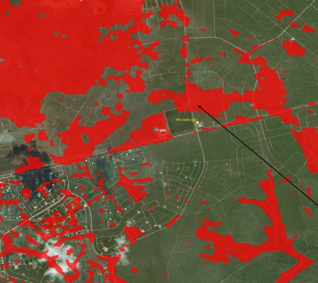
Figure 1. Storm-surge flooding (indicated in red) detected using a synthetic aperture radar satellite sensor through heavy cloud cover from the nearly stalled Hurricane Dorian (September 2019) over Grand Bahama Island. Two days prior, all but a small patch of land in this area was inundated with seawater. The underlying imagery in this figure was captured prior to the hurricane with a multispectral optical sensor.