After 13 years with the same seafloor-mapping system, the research vessel Nautilus from the non-profit Ocean Exploration Trust (OET) is surveying the deep Pacific around Wake Atoll, a U.S. territory located about 3,000 miles east of the Philippines.
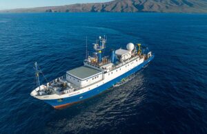
The research vessel Nautilus. [Credit: Ocean Exploration Trust, Nautilus Live]
One prominent upgrade is the EM304 MKII is a multibeam echo sounder from Kongsberg Discovery, a Norwegian ocean-technology company. Mounted to the ship’s hull, it sends out a fan of sound pulses and uses the returning echoes to calculate water depth and seafloor contours. In water 6,000 meters deep, it can map a strip 10 to 12 kilometers wide, more than twice the 4.5-kilometer swath covered by the sonar it replaced.
The ship also carries an environmental DNA sampler, which filters surface seawater for genetic material from marine organisms. The team will deploy Argo floats, robotic instruments that drift with ocean currents, repeatedly descend and rise through the water column, and transmit measurements such as temperature, salinity, oxygen, nitrate and pH by satellite.
“We are using a lot of new tech on this cruise in particular. Every year we have new pieces of equipment that we’re bringing out,” Expedition Leader Renato Kane said in an interview with R&D World.
To examine mapped targets close up, Nautilus deploys a tandem system of two remotely operated vehicles (ROVs), Hercules and Atalanta.
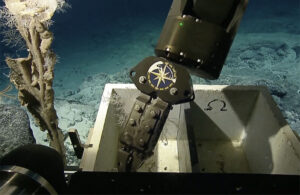
A still photo from the Hercules ROV on a dive, captured from a livestream. [Credit: Ocean Exploration Trust, Nautilus Live]
“We’ve been mapping over the Mariana Trench, and our previous unit couldn’t get to those depths, and now we can,” Kane said. “That’s really thrilling to see. To get that deep and be able to ‘see’ the bottom of the trench.”
As well as the hull-mounted sonar, Nautilus also has an ROV mounted multibeam sonar that they plan to use if they encounter any shipwrecks, Kane said. The expedition may be able to find shipwrecks from the Battle of Wake during World War II, a 16-day battle between American and Japanese forces.
Using the ROV-mounted sonar, the team can create three-dimensional models of the wrecks for later studies and to establish a baseline of their conditions to study how they may deteriorate over time.
“I think it’s personally one of my favorite tools,” Kane said.
The ROV-mounted sonar technology was used on a previous OET mission that explored Iron Bottom Sound, also the site of several World War II battles. As expedition leader on that trip, Kane has already seen the ROV-mounted sonar in action.
“We used it a lot last year when we were in Iron Bottom Sound off Solomon Islands, and what we can do is save time for navigation, and also create three-dimensional models for further study later and to archive,” he said.
Deploying tech along the way
The expedition deployed several devices during the ship’s travel from Guam to Wake Island and will deploy more as it travels from Wake to Hawaii at the backend of the trip.
Nautilus is carrying a Quokka eDNA sampler, developed by Australia’s national science agency, which filters surface seawater to autonomously collect DNA for biodiversity studies. The device pulls water from the ship’s underway system and automates the filtration and preservation of samples.
The crew also deployed three Argo floats, from the Global Ocean Biogeochemistry Array (GO-BGC), to support oceanographic monitoring. They will deploy three more as they travel from Wake to Hawaii at the end of the expedition.
“They constantly profile the ocean… They have a ballast system, and they’ll descend to about 2,000 meters and collect data on the way down and back up and then once they’re at the surface, they report that data to a satellite,” Kane said.
The floats measure temperature, salinity, pH, nitrate, chlorophyll, suspended particles and light, and derive measurements of partial pressure of CO2 (pCO2) and total alkalinity, according to GO-BGC’s website. GO-BGC has deployed 453 floats across the globe and the data is freely accessible.
Using telepresence, Nautilus is livestreaming all of its dives with live video from remote operated vehicles. The same technology allows them to bring in expertise from shore, Kane said. For this mission, that means having archeology experts on call during dives for shipwrecks.
As Wake is difficult and expensive to access, some of the deep-sea sites surveyed by Nautilus on this expedition may go years without another visit.
“It’s likely that no one will be here again in some of these places,” Kane said. “It’s kind of a unique glimpse in this exploration to a place that no one’s ever seen before.”