The NASA Alta X quadcopter in Missoula, equipped with a Langley-engineered structure, carries a radiosonde (left) and an anemometer (right), positioned to avoid rotor interference while maintaining stability. Credit: NASA/Milan Loiacono
As wildfire threats grow globally, NASA is tapping decades of aeronautics and Earth science expertise to support firefighters. Through its FireSense project — part of the Wildland Fires program — the agency is testing unmanned aerial systems (UAS) that gather real-time weather data over fire-prone areas. A recent field campaign in Missoula, Montana, demonstrated the drones’ ability to capture micrometeorology details, including wind speed, temperature, humidity, and air pressure at multiple altitudes.
Although these drones perform many of the same measurements as traditional weather balloons, FireSense isn’t meant to replace balloons entirely. Instead, NASA sees them as a complement, offering higher-frequency and more localized data to fill the gaps between routine launches. Missoula, with its mountainous terrain, erratic winds, and active nearby fires, served as an ideal testbed—providing the real-world variability needed to stress-test the system in smoky conditions.
Unlike traditional weather balloons—launched twice daily and subject to wind drift—NASA’s drone-based approach can repeatedly sample localized conditions throughout the day. This capability is crucial in wildfire situations, where shifting winds can rapidly escalate a blaze. Using standard radiosondes and anemometers familiar to the National Weather Service, the Alta X quadcopter offers a ready-to-deploy solution.
NASA chose the Alta X because the U.S. Forest Service (USFS) already operates a fleet of these drones and has trained pilots, lowering adoption barriers. To enable accurate readings, engineers at NASA Langley designed a custom mounting structure that keeps sensors—an anemometer and a radiosonde—far enough from the rotors to avoid data interference yet still maintains the drone’s stability. The anemometer, commonly found at weather stations, is effectively getting its first “wings” through this project.
By combining real-time sensor data with AI models from partners like MITRE, NVIDIA, and Esri, FireSense delivers detailed local conditions. This information helps crews allocate resources, predict fire growth, and mitigate risks while reducing reliance on disposable weather balloons.
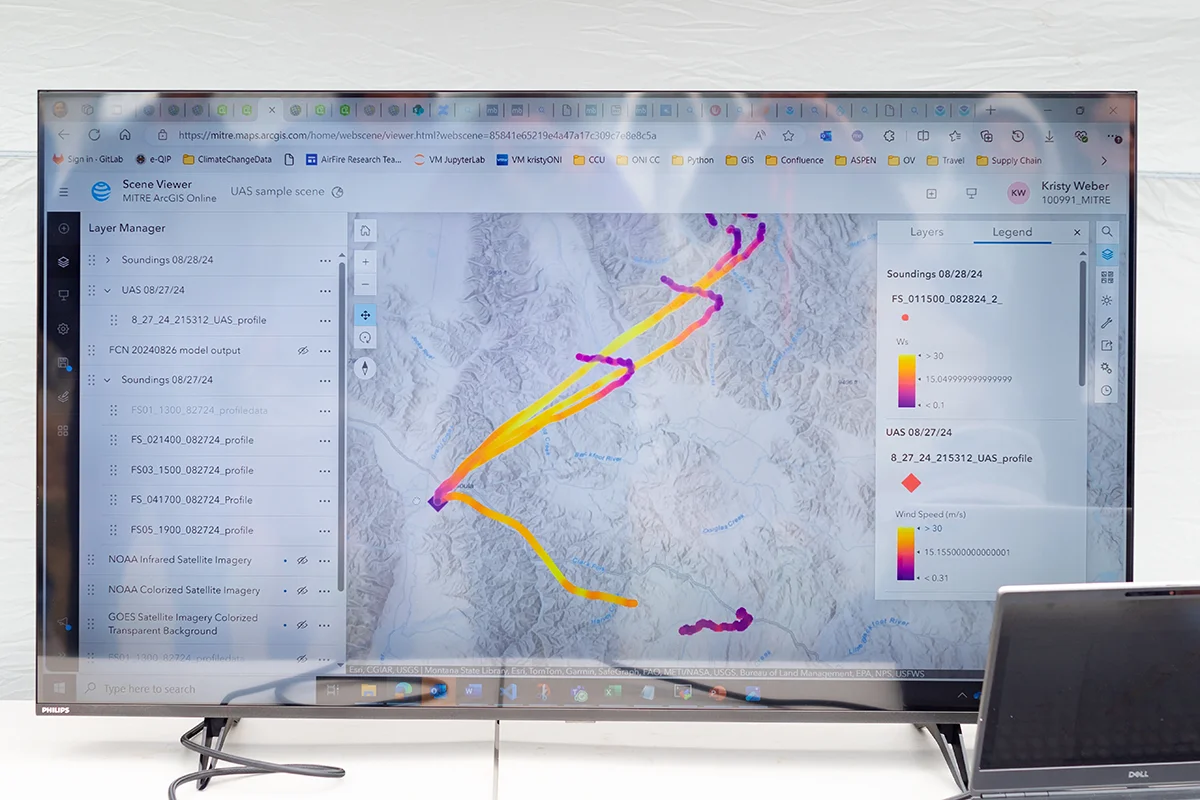
An early data visualization depicts the flight paths of weather balloons launched on the first day of the FireSense UAS technology demonstration in Missoula. In the image above, the paths are color-coded based on wind speed. Purple indicates low wind while bright yellow represents high.
Credit: NASA/Milan Loiacono
As wildfire seasons extend, agencies are increasingly using unmanned aerial systems for roles once filled by manned aircraft or ground stations. Beyond FireSense’s micrometeorology, drone fleets are being explored for search-and-rescue, post-burn assessments, and igniting prescribed fires to reduce fuel loads. NASA’s UAS Traffic Management research is also enabling safe drone integration into shared airspace, allowing rapid deployment without interfering with emergency efforts.
A key focus of FireSense is ensuring seamless integration into existing operational workflows. NASA is actively collaborating with agencies like the U.S. Forest Service and the National Weather Service to refine the drone systems and data products for practical use in real-world wildfire scenarios.
This campaign leveraged almost a decade of research, development, engineering, and testing. We have built up a UAS flight capability that can now be used across NASA.
Because each drone flight is reusable, there’s far less waste than a single-use weather balloon—a benefit when taking multiple measurements each day. Building on NASA’s broader UAS portfolio, from early wildfire imaging missions to the latest AI-driven modeling, FireSense could be an integral part of modernizing firefighting operations.
The Missoula campaign is just one step in NASA’s ongoing FireSense initiative. Building on these results, the team is already planning future deployments, including spring 2025 tests in Alabama and Florida, to assess drone performance in different fire environments and vegetation types. Beyond wildfire monitoring, the core technology and data insights developed through FireSense hold potential for broader applications, from improving air quality forecasts in urban areas to enhancing weather prediction for agriculture and disaster response. NASA also envisions this research not only transforming wildfire management but also contributing to a more comprehensive understanding of Earth’s atmosphere.