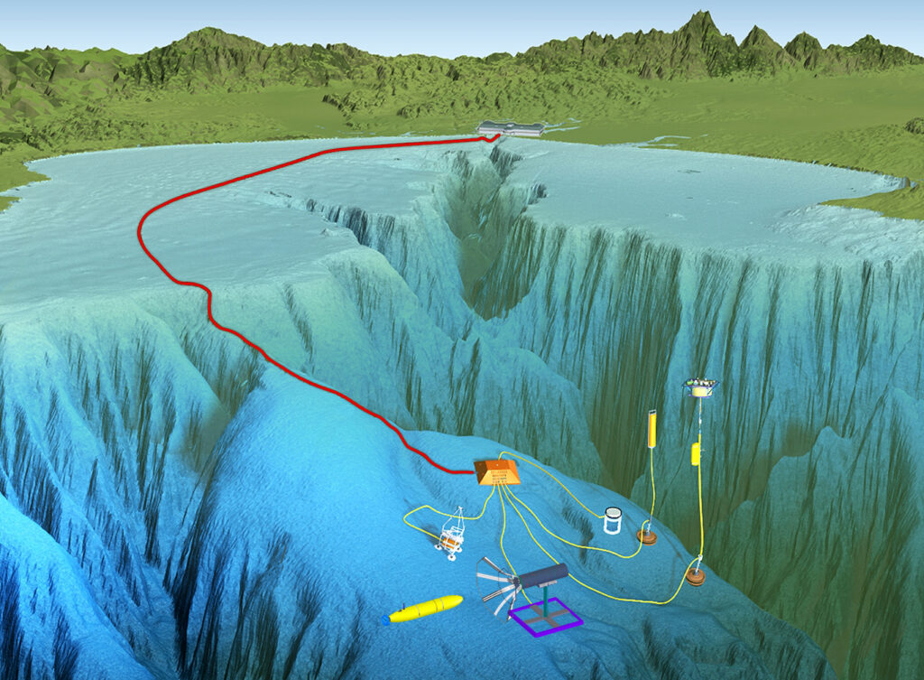
MBARI’s Monterey Accelerated Research System (MARS) connects seafloor instruments to shore through a roughly 51-kilometer power and fiber-optic cable (red line) ending at a node about 891 meters down. The Geo-Sense system described in the new paper takes the opposite approach. That is, a portable, battery-powered cable that records locally with no link to shore. Credit: MBARI
For eight days, a kilometer of fiber-optic cable on the floor of Monterey Bay became a temporary nervous system for one of the West Coast’s major submarine canyons.
The portable seafloor sensing system, deployed at roughly 380 meters depth in Monterey Bay, operated autonomously for eight days and detected all 32 earthquakes in the U.S. Geological Survey catalog within 150 kilometers, down to magnitude 0.82. A conventional ocean-bottom seismometer network caught 28 of the 32. Geo-Sense also recorded 26 transient events absent from the catalog, most of which were cross-confirmed by other instruments. The unit itself generated about 417 GB of raw data over the deployment, according to the paper, while the broader analysis drew on roughly 20 TB of archival recordings from MBARI’s much larger MARS distributed acoustic sensing array.

Ankur Verma, Ph.D.
“Typically this workflow would have taken a group of scientists and postdocs one to two years, because of [the data volume],” said Ankur Verma, Ph.D., CEO and co-founder of Lightscline, the State College, Pa. startup that handled the data processing. Verma said Lightscline received the data in early December and helped the team submit the manuscript by early February.
A portable array for canyon-scale listening
Unlike Monterey Bay Aquarium Research Institute’s nearby Monterey Accelerated Research System (MARS) observatory, which depends on a 52-kilometer power and data cable running back to shore, the Geo-Sense system runs on battery power and stores data locally. Described in a new Scientific Reports paper, the technique allowed researchers to place a distributed acoustic sensing array directly at seafloor sites of interest without relying on permanent cable infrastructure.
Monterey Canyon is one of the deepest submarine canyons on the West Coast, reaching depths comparable to the Grand Canyon just offshore from MBARI’s Moss Landing headquarters in the unincorporated community of Moss Landing. The institute has wired the canyon for science before: Its MARS observatory connects seafloor instruments to shore through a 52-kilometer power and fiber-optic cable terminating at a node 891 meters down.
Turning fiber into thousands of sensors
The fiber-optic cable, interrogated with pulses of laser light, becomes a defacto dense seismic and oceanographic array. “You can think of this sensor as 50,000 point sensors,” Verma said. “There’s an interrogator that sends pulses of light, we capture those pulses back, and we make inferences about oceanographic phenomena and earthquakes.” Minute changes in the backscattered light reveal strain along the fiber, enabling the detection of even micro-earthquakes.
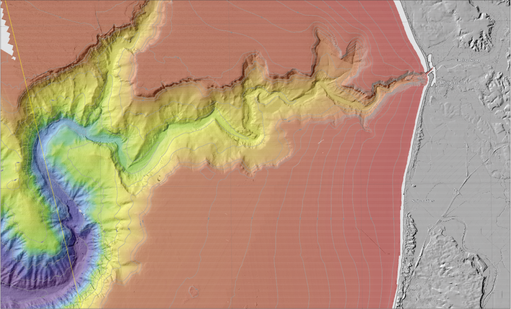
Bathymetry of Monterey Canyon and the Soquel Canyon Tributary, courtesy of the U.S. Geological Survey. Credit: U.S. Geological Survey
Compressing the analysis workflow
Lightscline first focused on discovery in the Geo-Sense deployment. In essence, their approach is to process the data, find the signatures, then decide what could be reduced in future deployments. “Earthquakes typically have P waves and S waves,” Verma said. “It’s not like random noise. There is some structure in that, and we can train our models to exploit that structure.”
The processing itself was deliberately conservative involving bandpass filtering, normalization and spatial or temporal averaging to knock down channel-dependent noise, with earthquake comparisons run through a consistent 3-40 Hz filter across Geo-Sense, the MARS DAS array and a nearby ocean-bottom seismometer.
Rendering a single multi-day spectrogram or frequency-wavenumber plot can mean loading hundreds of files, each running from hundreds of megabytes to gigabytes, and the team often needed many such views, layered with NOAA and ocean-current data, to tell an earthquake from a wave from an instrument artifact.

Ayush Goyal, Ph.D.
Using redundancy to separate signal from noise
Ayush Goyal, Ph.D., Lightscline’s co-founder and chief technology officer, said the redundancy across channels is what makes noisy seafloor data tractable. Each sensor alone wouldn’t provide a coherent signal singly. “But because you have thousands of them, you have algorithms to increase the aperture,” Goyal said. “For example, in space you have a lot of telescopes and you combine the data from a lot of telescopes. That’s sort of the idea.”
The same physics that lets thousands of mediocre channels resolve a magnitude 1 tremor also tells the team when the instrument itself has failed. An earthquake should light up every well-coupled channel simultaneously; in one subsequent MBARI deployment, the signal vanished partway down the cable, and the channel-response pattern pointed to a strain event, a section of fiber stretched during deployment, rather than a quiet seafloor.
Scaling sensing across existing cable networks
The Monterey deployment used a purpose-built cable, but the seafloor is already wired. Submarine fiber carries more than 99% of the world’s internet traffic, and the same interrogation technique can turn those routes into sensing arrays. The practical limits are span length, since repeaters divide long-haul cables into segments of roughly 60 to 80 kilometers, and the software to keep up with what the fiber records. Verma said Lightscline has already analyzed multi-span data released through the Ocean Observatories Initiative’s Regional Cabled Array and found the same signal quality it validates against in Monterey Bay.
The partnership with MBARI may unlock more deals in the long run, Verma says, recalling a conversation with a hyperscaler saying to reach out once Lightscline had “something at 10,000-kilometer scale,” roughly the span of its own transoceanic routes.
The technology is also relevant in chokepoints such as the Strait of Hormuz, where conflict has disrupted shipping and raised concern about the undersea cables that connect the Gulf to Europe and Asia. Passive fiber sensing would add another layer of awareness to such regions.
“If you look at a map of the world, there are so many submarine cables,” Goyal said. “You can think of it as monitoring what’s happening underwater all over the world. It’s sensing what’s happening with the planet at that scale.”