Researchers from Beijing Normal University and East China Normal University have developed a new disaster detection framework called Single-temportal High-spatial resolution image Individual unsupervised change Detection (Shield). They published their research in the Journal of Remote Sensing. The system allows satellites to detect disaster-affected areas directly in orbit. By combining change detection and anomaly detection, the method can quickly analyze satellite images and transmit only essential information to ground stations, improving the efficiency and timeliness of disaster monitoring.
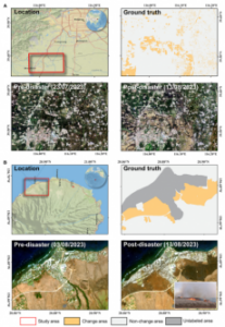
Spatial distribution of the 2 large-scale disaster events in 2023 along with true-color images and ground truth of disaster-affected areas. (A) Zhuozhou flood in China and (B) Hawaii wildfire in the United State. Credit: Chinese Academy of Sciences
Natural disasters such as floods, wildfires and landslides pose increasing risks to human safety and infrastructure, particularly as extreme weather events become more frequent. Satellite remote sensing plays a crucial role in monitoring disasters and assessing their impacts over large geographic areas. However, most disaster detection methods rely on ground-based processing and require multiple satellite images captured before and after the event. These approaches often demand large storage capacity, intensive computation and frequent data transmission between satellites and ground stations. Such requirements limit their use for real-time monitoring directly on satellites.
How Shield simplifies detection with single-image analysis
Unlike conventional techniques that require multiple temporal images, Shield only needs a single post-disaster image combined with lightweight prior knowledge derived from pre-disaster data. The autoencoder (AE) neural network used in Shield is 381 times smaller than popular Earth-observation foundation models.
The researchers conducted experiments for landslides, floods, wildfires and deforestation. Results showed that Shield consistently outperformed 10 widely used change detection and anomaly detection methods. The model improved the average F1 accuracy score by approximately 24.37% across different disaster scenarios and land-cover conditions. In large-scale case studies, Shield reduced data storage requirements by five to 239 times and increased detection speed by up to 136 times.
A leaner approach to identifying anomalies in orbit
Shield operates through a two-stage workflow designed for resource-limited satellite environments. First, prior knowledge is extracted from pre-disaster imagery using a lightweight autoencoder neural network that learns deep spectral-spatial features from satellite images. These features are clustered through an unsupervised K-means algorithm to generate land-cover categories and statistical feature distributions for each category are estimated to represent normal surface conditions.
When a new satellite image is captured after a disaster, the model extracts deep features and compares them with the stored distributions. The Mahalanobis distance is used to measure deviations between the post-disaster features and baseline distributions, allowing the system to identify abnormal changes that likely correspond to disaster-affected areas.
A two-step localization strategy then detects both patch-level and pixel-level changes, enabling the model to locate large impacted regions while maintaining computational efficiency. The framework was evaluated using datasets from Brazil, Russia, China and New Zealand covering landslides, floods, wildfires and deforestation, as well as two large-scale disaster events: the 2023 Zhuozhou flood in China and the 2023 Hawaii wildfire.
The approach allows satellites to process images directly in orbit and transmit only key information about disaster impacts. This capability could significantly improve response speed and reduce the burden on satellite communication systems during emergency monitoring.
Experiments showed the model’s performance begins to decline if the disaster-affected area exceeds 30% of the total image. If the disaster covers more than 50% of the scene, the method becomes largely ineffective.
The future of autonomous Earth observation
The study employed a lightweight autoencoder neural network to extract deep features from satellite images. The framework was evaluated using high-resolution imagery from Google Earth and PlanetScope satellites, with ground-truth maps manually interpreted by remote-sensing experts.
The Shield framework could significantly enhance next-generation Earth-observation satellites by enabling near-real-time disaster detection directly in orbit. The method reduces data transmission needs and computation burden while maintaining high detection accuracy. In the future, the approach could support rapid monitoring of floods, wildfires, landslides and environmental changes worldwide. Researchers also suggest that similar techniques could be applied to broader remote-sensing tasks, including land-use change detection and ecosystem monitoring.