The Qinghai-Tibet Plateau, commonly referred to as the “Third Pole,” is undergoing significant environmental changes. Its alpine wetlands, crucial for regional biodiversity and water regulation, exhibit signs of distress, including diminishing water resources and degradation of meadows. However, persistent cloud and snow cover complicate consistent, long-term monitoring of these ecosystems. Researchers from South China Normal University, Tibet University, and the Chinese Academy of Sciences have created a new tool to tackle this issue.
Credit: Journal of Remote Sensing
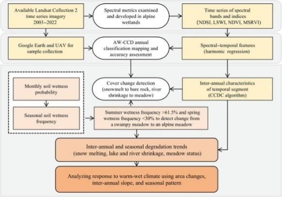
Flowchart for mapping and analysis of the Maidika Wetland. AW-CCD, continuous classification and degradation detection algorithm for alpine wetlands; NDSI, normalized difference snow index; LSWI, land surface water index; NDVI, normalized difference vegetation index; MSRVI, meadow spectral ratio vegetation index; CCDC, continuous change detection and classification.
Published in the January 2, 2025, issue of the Journal of Remote Sensing, the Alpine Wetlands Change Detection (AW-CCD) algorithm uses Landsat time series data to monitor ecosystem changes on the cloud-covered Qinghai-Tibet Plateau. The framework aims to classify wetlands annually and track degradation by integrating long-term inter-annual data with seasonal soil moisture indicators. This method improves snow cover detection by 5% and meadow classification by 3%, achieving a mapping accuracy of 94.9% in the Maidika Wetland in 2022.
The study reveals significant environmental shifts over the past two decades. Snow and river areas in the Maidika Wetland decreased by 5.04% and 16.74%, respectively, while 3.23% of swampy meadows transitioned into drier alpine meadows. The most severe degradation occurred before 2009, followed by a stabilization period until 2015 and a resurgence in recent years. To capture these changes, the AW-CCD algorithm uses spectral-temporal index features, such as the Normalized Difference Snow Index (NDSI) for snow detection and the Meadow Spectral Ratio Vegetation Index (MSRVI) for differentiating meadow wetness.
The research team analyzed Landsat images from 2003 to 2022, using the Fmask algorithm to minimize cloud and shadow disruptions. Elevation and slope data from the Shuttle Radar Topography Mission, ALOS World 3D-30m, and Global Surface Water data further enhanced classification accuracy.
Dr. Yingchun Fu, a lead scientist on the project, highlighted the broader implications of the findings: “The AW-CCD framework not only enhances our capacity to monitor alpine wetlands but also deepens our understanding of how these ecosystems are responding to climate change. This technology could fundamentally reshape conservation efforts in high-altitude regions.”
The AW-CCD framework’s ability to provide detailed, accurate, and timely data on wetland degradation could inform policymakers and conservationists, helping to mitigate ecological damage and protect biodiversity in alpine regions. This research advances the field of remote sensing and contributes to global environmental conservation efforts.
Broader use of satellite data for environmental monitoring
Satellite data has become a cornerstone of environmental monitoring, with numerous labs and companies leveraging it to track ecological changes. For example, U.S. Geological Survey’s (USGS) Landsat program and the European Space Agency’s Sentinel missions provide critical data for monitoring deforestation, glacier retreat, and urban expansion. Private companies like Planet Labs and Maxar Technologies also use high-resolution satellite imagery to support environmental assessments and disaster response.
In wetland monitoring specifically, organizations like the USGS and the United Nations Environment Programme (UNEP) use satellite data to track water levels, vegetation health, and land-use changes. These efforts help identify areas at risk of degradation and inform conservation strategies. Similarly, the Global Wetland Outlook by the Ramsar Convention relies on satellite-derived data to assess the status of wetlands worldwide.
The AW-CCD framework adds to this growing work by addressing the unique challenges of monitoring cloud-covered, high-altitude regions. Its success underscores the potential of combining spectral-temporal analysis with advanced algorithms to improve our understanding of complex ecosystems threatened by climate change.