Maintaining large-scale infrastructure is becoming increasingly challenging as urban populations expand and extreme weather events occur more frequently. Waste landfill facilities, in particular, present difficulties for managers with limited on-site access, resulting in various issues, including environmental pollution.
Tapping into free satellite data, the Korea Institute of Civil Engineering and Building Technology (KICT) has developed a maintenance technology that uses satellite Synthetic Aperture Radar (SAR) data. This technology offers a cost-effective method for wide-area surveys based on high-resolution images generated by SAR. Because SAR uses microwaves that can penetrate clouds and operate under most weather conditions, satellite data — such as those provided by the European Space Agency’s free Sentinel program — can be incorporated into maintenance strategies.
Dr. Sungpil Hwang and Dr. Wooseok Kim of KICT examined the impact of underground structures, including roads and subways, by analyzing surface subsidence caused by excavation and blasting. Their research indicates that the technology applies to various urban structural conditions and allows for widespread surface displacement monitoring.
credit: Korea Institute of Civil Engineering and Building Technology
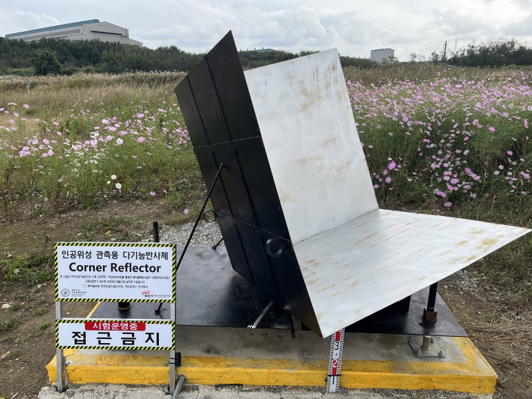
Prototype of scatterers installed on top of landfill facilities
How it works: Scatterers and accurate signal detection
In joint research with the University of Tokyo, the KICT team also tested the technology at a waste disposal facility to assess its suitability for landfill sites in 2024. Scatterers were applied to reduce the interference from trees in expansive landfill areas, producing data more than 15dB higher than those from surrounding areas. This improvement suggests more accurate maintenance of landfill facilities. If implemented, the technology is expected to cut maintenance costs by over 30% compared to existing methods and eliminate blind spots in facility management.
Dr. Hwang, the lead researcher, addressed the growing infrastructure challenges by stating, “The number of facilities requiring maintenance is increasing.” He added, “It is expected that using satellite SAR data will enable cost-effective and efficient maintenance.”
Real-world results: Busan and Seoul
In a Busan pilot project, portions of riverbank infrastructure subsided by a few centimeters within just six months — an issue quickly flagged by SAR monitoring. Meanwhile, trials in the Seoul metropolitan area showed similar promise for monitoring subway construction and underground roads, pinpointing risk zones that might otherwise be overlooked.
“Ultimately, by overlapping past and current satellite SAR data for time‐series analysis, it was confirmed that this approach could provide sustainable information for maintenance,” the Sustainability paper notes.
KICT plans to integrate this satellite‐based system into a wider maintenance platform that includes landfills, underground transportation routes, and other hard‐to‐access areas. By combining scatterers with SAR data, large‐scale facilities can be monitored consistently — even under extreme weather or remote conditions — helping stakeholders allocate resources more effectively and reduce the likelihood of costly, disruptive failures.
Benefits beyond cost savings
- Reduced Environmental Risk: Early identification of ground shifts can prevent leachate leaks and other forms of pollution.
- Safer Communities: More frequent, data‐driven checks can avert sudden failures in critical infrastructure.
- Scalable Approach: Because Sentinel‐1 SAR data are free, managers can expand monitoring without prohibitive new equipment costs.
For a deeper technical look, check out the article here: Identification of Risk Zones During Infrastructure Construction and Maintenance Using Satellite SAR Data for Sustainable Urban Areas in South Korea (Sustainability, 2024, 16(23), 10627, https://doi.org/10.3390/su162310627)