Researchers said they believe they have discovered the largest exposed fault on Earth. (Credit: Australian National University)
Geologists say they have discovered the largest exposed fault on Earth in eastern Indonesia.
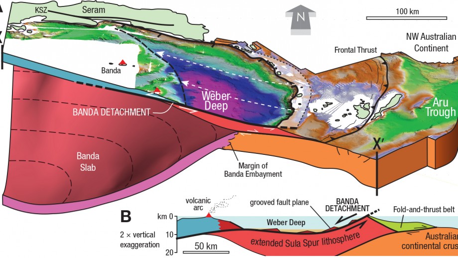
Led by Jonathan Pownall, Ph.D., from the Australian National University, researchers believe they have discovered a fault below the Banda Sea covering at least 60,000 kilometers.
“The abyss has been known for 90 years but until now no one has been able to explain how it got so deep,” Pownall said in a statement. “Our research found that a seven km-deep abyss beneath the Banda Sea off eastern Indonesia was formed by extension along what might be Earth’s largest-identified exposed fault plane.”
Pownall said he believes that by studying the Banda Detachment fault they can better assess the dangers of future tsunamis in the Pacific Ring of Fire—which is particularly vulnerable to earthquakes and volcanic eruptions.
“In a region of extreme tsunami risk, knowledge of major faults such as the Banda Detachment—which could make big earthquakes when they slip— is fundamental to being able to properly assess tectonic hazards,” he said.
Geologists from ANU and Royal Holloway University of London were able to analyze high-resolution maps of the Banda Sea floor and discover that the rocks flooring the seas are cut by hundreds of parallel scars. These wounds show that a large crust must have been ripped apart by 120 km of extension along a low-angle crack or detachment fault, to form the present-day ocean-floor depression.
“The discovery will help explain how one of the Earth’s deepest sea areas became so deep,” Pownall said.
Prof. Gordon Lister, from the ANU Research School of Earth Sciences, said this was the first time the fault has been observed and documented.
“We had made a good argument for the existence of this fault we named the Banda Detachment based on the bathymetry data and on knowledge of the regional geology,” Lister said in a statement.
Pownall was able to observe prominent landforms consistent with surface extensions of the fault line while on a boat in eastern Indonesia in July.
“I was stunned to see the hypothesized fault plane, this time not on a computer screen, but poking above the waves,” he added.
According to Pownall, rocks immediately below the fault include those brought up from the mantle.
“This demonstrates the extreme amount of extension that must have taken place as the oceanic crust was thinned, in some places to zero,” he concluded.
The study, which was published in Geology, can be viewed here.