A still from the Google video: https://www.youtube.com/watch?v=UZ4RaLGDXI4&t=1s
Google today introduced a geospatial reasoning system that automates complex environmental analysis, moving its Earth AI platform beyond static data layers toward dynamic decision support. A paper on the system was published in arXiv. The new framework orchestrates multiple specialized AI models to answer multi-step questions about disaster response, public health and infrastructure planning. Open today to trusted testers, the platform enables users to make myriad queries for everything from fairy circles to disaster scenario planning for wildfires, floods and beyond. Google is touting the system as a natural language interface for Earth observation.
During press demonstrations in Mountain View, California, Google representatives showed the system working through a Hurricane Helene scenario: starting with a five-day cyclone forecast. The agent identified Florida counties with populations exceeding 20,000 in the highest-wind path, calculated vulnerability scores from unemployment and health insurance data, then mapped hospitals and power stations in the most at-risk areas. As company representatives noted, the workflow enables researchers to ask “what-if” questions instead of just “what is,” with the Gemini-powered system automatically connecting weather forecasting, population dynamics and satellite imagery models to synthesize answers in minutes.
We’re working to train Earth AI models to reason about the physical world as fluently as LLMs reason about the digital one. —Yossi Matias, VP & GM of Google Research in an announcement.
Three major capabilities launching today
The October 23 release includes three key developments. According to the arXiv paper, the Gemini-powered framework achieved an overall score of 0.82 ± 0.02 on benchmark fact-finding and analytics tasks, significantly outperforming baseline Gemini configurations at 0.50 ± 0.01. The agent automatically chains specialized models to answer complex queries that previously required weeks of expert analysis.
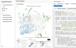
The software can also help with object detection. An experimental open-vocabulary imagery model trained on U.S. satellite data responds to free-form search requests. As mentioned earlier, the system can surface examples of “fairy circles” by aligning text embeddings with visual features. Results return with timestamps enabling change detection across historical imagery in Google Earth’s time slider. This capability enters Google Earth Professional and Advanced in the coming weeks for U.S. users.
Finally, the company is planning expanded access on Google Cloud. Earth AI Imagery, Population, and Environment models are now available to Trusted Testers, allowing organizations to combine proprietary data with Google’s planetary-scale datasets for custom analyses including historical sweeps and deforestation tracking.
The technical foundation rests on AlphaEarth, which provides annual 10-meter embeddings available in Earth Engine, with 64 bands per image.
Measurable gains when models collaborate
Google’s research demonstrates quantifiable improvements when models work in concert. For disaster preparedness, combining AlphaEarth’s landscape embeddings with Population Dynamics’ socioeconomic signals increased average R² by 11% across 20 FEMA risk indices. On 21 CDC health indicators, the multi-model approach beat single-model baselines by 7% versus Population alone and 43% versus AlphaEarth alone, capabilities the WHO Regional Office for Africa is now using for cholera prevention in Democratic Republic of Congo. In hurricane damage prediction, a partner model forecast 2,575 damaged buildings versus 2,496 observed—approximately 3% error—three days before Hurricane Ian’s landfall. For disease forecasting, adding weather and population data to Google’s TimesFM model cut error by roughly 34% for cholera nowcasting. Population Dynamics now covers 17 countries with monthly resolution over two years, improving tracking of migration patterns and demographic shifts.
Open-vocabulary search addresses the training data bottleneck
The imagery capabilities address a longstanding constraint: traditional object detection required thousands of labeled examples for each category. The new vision-language architecture learns relationships between image features and text descriptions during pre-training, then generalizes to novel queries at inference time.
Demonstrations in Mountain View included searches for ancient tombs, cemetery patterns and building damage. Results include timestamps for verification against historical imagery. This enables environmental queries for dried riverbeds, algae blooms or vegetation encroachment without retraining models for each detection task.
Why this matters for research and industry
For research teams, utilities, insurers, and infrastructure operators, the shift from map layers to automated answers is poised to transform workflows. In environmental monitoring, prompt-driven searches for dried riverbeds and algae blooms flag dust-storm risk and drinking-water hazards earlier, with timestamps for trend analysis against historical imagery. For infrastructure and claims, grid operators can detect vegetation encroachment on power lines to prevent outages, while insurers pre-score property damage ahead of landfall—the Hurricane Ian model’s 3% error rate three days before impact demonstrates practical lead times for resource allocation. In public health applications, sub-national nowcasting becomes a practical fusion of environmental drivers with population exposure. The DRC cholera model’s 34% error reduction when combining weather and population data shows measurable gains from multi-modal integration, supporting targeted intervention campaigns.
Google also previewed Firesat, a planned constellation to scan Earth every 20 minutes and detect wildfires as small as 5-by-5 meters, about the size of a classroom, for early containment.