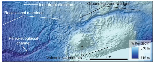
An example of seafloor bathymetry data that Rice University oceanographers used to identify a paleo-subglacial channel, grounding line landforms, volcanic seamounts and other features used in their study. (Image courtesy of L. Simkins/Rice University)
Hidden, underground rivers in Antarctica may play a key role in determining the fate of Antarctic ice streams.
Researchers from Rice University have discovered hidden rivers in Antarctica after spending two years analyzing sediment cores and precise seafloor maps covering 2,700 square miles of the western Ross Sea.
The researchers found that as recently as 15,000 years ago, the area was covered by thick ice that later retreated hundreds of miles inland to its current location.
The new maps showed that the ice retreated during a period of global warming after the last ice age on Earth and in several places there were not just river systems, but also subglacial lakes that fed the ancient water courses.
Modern Antarctica is covered by ice that is more than two miles thick in some places. However, the ice is not static and gravity compresses it and moves it under its own weight to create rivers of ice that flow to the sea.
Scientists have had difficulty understanding the undersides of massive ice streams because they are rarely accessible to direct observation.
“One thing we know from surface observations is that some of these ice streams move at velocities of hundreds of meters per year,” Lauren Simkins, a postdoctoral researcher at Rice and lead author of the study, said in a statement. “We also know that ice, by itself, is only capable of flowing at velocities of no more than tens of meters per year.
“That means the ice is being helped along. It’s sliding on water or mud or both,” she added.
According to Simkins, the fossilized river system offers a different picture of how Antarctic water drains from subglacial lakes through rivers to the point where ice meets the sea.
“The contemporary observations we have of Antarctic hydrology are recent, spanning maybe a couple decades at best,” she said. “This is the first observation of an extensive, uncovered, water-carved channel that is connected to both subglacial lakes on the upstream end and the ice margin on the downstream end.
“This gives a novel perspective on channelized drainage beneath Antarctic ice,” Simkins added. “We can track the drainage system all the way back to its source, these subglacial lakes and then to its ultimate fate at the grounding line, where freshwater mixed with ocean water.”
Meltwater builds up in subglacial lakes and intense pressures from the weight of ice causes some melting. With several volcanoes heating ice from below, Simkins and Rice co-author and volcanologist Helge Gonnermann confirmed that volcanoes could have provided the necessary heat to feed the lakes. Simkins found at least 20 lakes in the fossil river system, along with evidence that water built up and drained from the lakes in episodic bursts as opposed to a steady stream.
The discovery may lead to new ice maps that show exactly how ice retreated across the channel-lake system, allowing hydrologists and modelers to better predict how today’s ice streams behave and how much they contribute to rising sea levels. The researchers also found the retreating ice streams in the western Ross Sea made a U-turn to follow the course of an under-ice river—the only documented example on the Antarctic seafloor where a single ice stream reversed retreat direction to follow a subglacial hydrological system.