NASA’s Cyclone Global Navigation Satellite System (CYGNSS), which launched in 2016, is deorbiting on New Year’s Day. The technology will live on, commercialized by Muon Space, a Silicon Valley startup that grew out of a Stanford class project.
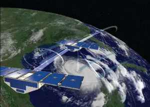
The eight-satellite CYGNSS constellation, shown here early in its mission. Credit: NASA
The satellites lack propulsion systems, so they have been steadily losing altitude since launch. They would naturally deorbit sometime next year, burning up on reentry, but NASA decided to accelerate the process and bring them down on January 1, 2027.
“We just want to get them out of the air, just because of orbital debris and collision, all these kinds of things, and they’re really small, so they’ll definitely just burn up in the upper atmosphere,” Chris Ruf, Frederick Bartman Collegiate Professor of Climate and Space Sciences and Engineering at the University of Michigan, and principal investigator of CYGNSS, said in an interview.
The satellites will collect one last full day of data on December 31, Ruf said. They were originally designed without propulsion systems to save on the cost, allowing the scientists to fund more smaller satellites rather than fewer large ones.
“We’re going to program the satellites to increase atmosphere drag by tilting the solar panels, and the drag goes up by about 600% when you do that, and they’ll come down much faster,” Ruf said.
Inside the mission
The same cost-consciousness that left CYGNSS without propulsion also made it commercially replicable. The satellites don’t actually transmit their own signals; instead, receiving reflected GPS signals from other satellites.
“95% of the cost [of other satellites] is just that transmitter, because it’s the thing that needs a lot of power, and power is everything in space. You need more power, you need a bigger solar panel, you need a bigger satellite, you need a bigger rocket to get it up there and everything just snowballs,” Ruf said.
The CYGNSS team took GPS receivers designed for navigation and reprogrammed them to measure GPS signals after they’ve reflected off the surface of the Earth.
“When [the signals] reflect off the ocean, they get distorted by the waves, and from that we can measure the distortion, and from that we can figure out how rough the ocean surface is, and from that we can figure out how windy it is,” Ruf said.
GPS signals are useful for this purpose because they travel through rain.
“When [GPS] was originally invented by the US military, it was designed to be all-weather performance… so they intentionally chose frequencies to operate at that were insensitive to rain,” Ruf said.
By omitting the propulsion system and transmitter, the team made the CYGNSS satellites cheap enough that they could afford to fly eight of them.
“When you have that many satellites, you come back around to the same spot on the ground much more often, eight times more often, basically… we cover everywhere in the world, in the tropics, between three and four times a day,” Ruf said.
This affordability was also exactly what made the technology commercially viable.
How a class project came to license the technology
Muon Space, the startup that licensed the CYGNSS technology, started as a Stanford class project.
“I actually didn’t know they were working on it at the time. They just read my papers, and it was just going to be some student project,” Ruf said.
Then the students graduated, got seed funding from venture capital, and started the company. They contacted Ruf when the company had about 30 employees and asked him if he wanted to get involved, Ruf said.
He’s been an advisor to the board since and the University of Michigan licensed CYGNSS-related IP to the company.
Muon builds and operates its own satellite platform, Condor-M, and has diversified past the CYGNSS-style wind sensing it started with. The company’s highest profile product is now FireSat, a wildfire-detection constellation built with the nonprofit Earth Fire Alliance that is being tested by fire agencies on three continents, including Cal Fire, according to the company’s website.
The CYGNSS technology licensed from the original mission is now on its third generation of receivers at Muon, which improved them with dual-polarization antennas and larger antennas that extend wind-speed sensitivity to Category 5 hurricanes.
“[CYGNSS] would have run out of steam anyway next year, so I don’t really feel that bad about it, and also I feel way less bad about it, knowing that there’s all these new missions going up that are carrying on, and not just carrying on, but improving on it,” Ruf said.