Disturbances on Earth, from thunderstorms to earthquakes, send ripples into the upper atmosphere, disturbing the region that low-Earth-orbit satellites fly through and that GPS and communications signals must cross.
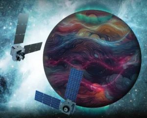
Artist’s rendition of the DAPHNE (Dynamic Atmosphere-Ionosphere Explorer) mission concept. The coloring represents auroras and atmospheric waves in Earth’s atmosphere.
Credit: Laboratory for Atmospheric and Space Physics/Mary Tostanoski
“Think of waves as throwing a pebble into a body of water, and you see those waves propagate out in a circle. That’s what happens in our atmosphere all the time,” said Aimee Merkel, principal investigator of the DAPHNE mission and research scientist at the Laboratory for Atmospheric and Space Physics (LASP) at the University of Colorado Boulder.
NASA recently selected the DAPHNE mission to address a gap in space weather research: how lower-atmosphere weather affects the upper atmosphere and what drives conditions during quiet times.
NASA says the resulting data will help forecasters better predict and mitigate the effects of space weather on GPS systems, satellites in low Earth orbit, communications and astronauts as the agency prepares for future missions.
In February 2022, a geomagnetic storm that registered as a G1, the lowest rating on NOAA’s five-step scale, thickened the upper atmosphere enough to increase drag on a batch of newly launched Starlink satellites by up to 50%. SpaceX lost 38 of the 49 spacecraft within days. Researchers later traced the cause to enhanced atmospheric density at the same altitudes DAPHNE is designed to observe.
“By providing new insights into Earth’s atmosphere, we can better predict and prepare for impacts in our daily lives on Earth and in space,” said Nicky Fox, associate administrator of NASA’s Science Mission Directorate, in a statement.
How Earth’s weather climbs to the thermosphere
Scientists previously thought that lower atmosphere waves only reached as high as 50 to 100 kilometers, until data from the 2000s and 2010s found positive correlations between gravity wave distributions in the middle atmosphere and thermosphere.
Researchers found two pathways: fast waves that propagate directly from the troposphere to the thermosphere and primary waves that dissipate on the way up and generate secondary waves that reach the thermosphere. A 2024 study found that most quiet-time thermospheric gravity waves have intrinsic speeds too fast to have been generated directly in the lower or middle atmosphere.
These waves come from thunderheads, earthquakes, hurricanes and even winds going over mountain ranges, Merkel said.
“What we know is through models, we just don’t have a lot of observations in that region of the atmosphere,” she explained. And that’s where DAPHNE comes in.
The DAPHNE mission
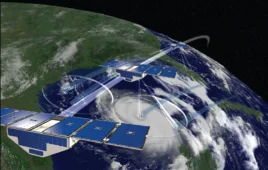
The DAPHNE mission, or Dynamic Atmosphere-Ionosphere Explorer, will use identical twin satellites to study how changes in Earth’s lower atmosphere influence the upper atmosphere, where space weather is manifested.
Each satellite will be equipped with three remote-sensing instruments: MIGHTI, FUVI and PLATO. Together, the instruments will provide coordinated, multi-point measurements of neutral winds, temperature and composition at 100 to 300 kilometers above the ground.
The two satellites will provide more robust observations than one could alone, Merkel said. A single satellite takes 60 to 80 days to collect data from all local times, she explained.
“By having two satellites, we’re able to get four local times a day, and then we can get to all the dynamics much faster,” Merkel said. The two satellites will also provide “more than one viewpoint… way more multi-point observations at the same time, and we absolutely need that to even get close to a handle on what’s going on on a day-to-day basis, instead of a month-and-a-half basis.”
Why DAPHNE looks down instead of diving in
The satellites will fly at approximately 600 kilometers above the ground, using remote sensing to measure what’s happening at 100 kilometers to 300 kilometers. This is for two reasons: drag makes it hard to fly a satellite in that region, and in-situ data is much more localized. DAPHNE was designed to do remote sensing for a clearer picture of the area, Merkel said.
“The ultimate goal, way down the line, would be to have a whole bunch of satellites in this region of the atmosphere that we can take that in situ data… that needs to happen, and that will happen with a different satellite constellation,” Merkel said. “If you’re measuring directly in the region that you are, you really have to have a large constellation to fill that space, because it’s so localized. With our observations, it’s more global. We’re able to cover more area with this technique.”
The satellites will use three specialized instruments to collect data on the atmospheric waves. MIGHTI measures winds and temperature, FUVI images the atmosphere’s ultraviolet glow to track daytime and nighttime emissions and PLATO profiles temperature and composition along the horizon behind each spacecraft.
Satellites are headed where the data isn’t
Very low Earth orbit, which has historically been avoided because atmospheric drag quickly pulls satellites down, is drawing new interest from commercial and defense operators, who are developing spacecraft designed to fight the drag and stay there.
“They’re going to be flying more satellites in this region of the atmosphere, where we weren’t able to before, and they’re engineering ways to have propulsion to keep satellites up in this region,” Merkel said.
Those operators will need to know what the atmosphere is doing on ordinary days, not just during solar storms, and that, Merkel said, is precisely what scientists can’t yet predict.
“You think quiet time, there are no storms, and we just go about our day, and our satellites are safe. But we now know that even during quiet time conditions, where the sun isn’t influencing the atmosphere, our Earth can influence that region in the atmosphere,” Merkel said.
The road to a 2029 launch
NASA selected DAPHNE over two other mission concepts to move to Phase B. During Phase B, the team will reassess and finalize the mission’s top-level requirements and the design of the satellites and instruments.
Phase B allows the team “to make sure that we set up the mission to move forward successfully once we get into the build phase because it’s really hard once you’re in the build phase to then go back and say, oh, we should have had this requirement instead,” Merkel said.
At the end of Phase B, the mission will undergo a confirmation review with NASA before moving to Phase C. If confirmed, the total cost of the mission, excluding launch, will not exceed $250 million in fiscal year 2023 dollars. The mission would launch no earlier than 2029.